New paper: Providing quality-assessed and standardised soil data to support global mapping and modelling
A new open access paper titled “Providing quality-assessed and standardised soil data to support global mapping and modelling (WoSIS snapshot 2023)”, with ISRIC – World Soil Information senior soil science expert Niels Batjes as lead author, was recently published in Earth System Science Data.
Access the paper here
The paper discusses the static, “December 2023 snapshot” derived from WoSIS (World Soil Information Service). A major improvement has been the harmonisation of the WoSIS data model to the ISO 28258 and O&M (observations and measurements) domain models. Re-factored ETL (extract, transform, load) procedures greatly improved the data ingestion and standardisation process. New datasets, with a focus on forest soils, were shared by a diverse range of data providers. Novel ways for visualising, querying and serving the standardised data were developed to facilitate their use by a wide user community; ISRIC is a regular member of the ISC World Data System.
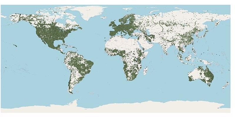
The snapshot comprises quality-assessed and standardised data for 228,000 geo-referenced profiles. The profiles come from 174 countries and represent more than 900,000 soil layers (or horizons) and over 6 million records. The number of measurements for each soil property vary between profiles and with depth, this generally depending on the objectives of the original field sampling programmes. Three measures for “fitness for intended use” are provided to facilitate informed data use.
“We are very grateful to those who were able to openly share soil data for consideration in WOSIS”, said project leader Niels Batjes, “regrettably, however, we noticed that increasingly soil sampling and monitoring programmes tend to focus on the top 30 cm of soil only and that adoption of open data sharing principles seems to become less common.”
WoSIS-served soil data can be used to underpin predictive soil property mapping and a diverse range of environmental assessments at a broad scale level. Such information can help inform global conventions so that policymakers and business leaders can make informed decisions about the environment, biodiversity, and human well-being at an appropriate scale level.
Full citation: Batjes, N. H., Calisto, L., and de Sousa, L. M, 2024. Providing quality-assessed and standardised soil data to support global mapping and modelling (WoSIS snapshot 2023), Earth Syst. Sci. Data, 16:4735-4765. https://doi.org/10.5194/essd-16-4735-2024
As indicated in the paper, there are still numerous gaps in the data represented in WoSIS. Please help ISRIC to fill these gaps ―for the greater benefit of the international community― by sharing (some of) your soil profile data for consideration in WoSIS. Thank you.
