FAQ - WoSIS
Contents
- What is WoSIS?
- Which soil properties are standardised?
- Towards soil data harmonisation
- What do the attribute codes mean?
- What measures for 'fitness-for-intended-use' are provided?
- How can I access data derived from WoSIS?
- Are there any tutorials?
- What is the WoSIS data-sharing policy?
- How can I help improve WoSIS?
- Who shared soil profile data for inclusion in WoSIS?
- Who contributed to the development of the WoSIS database?
- Future developments
- How should the WoSIS datasets be cited?
- What if I could not find an answer to my question?
- Acknowledgements
- Main references
![]()
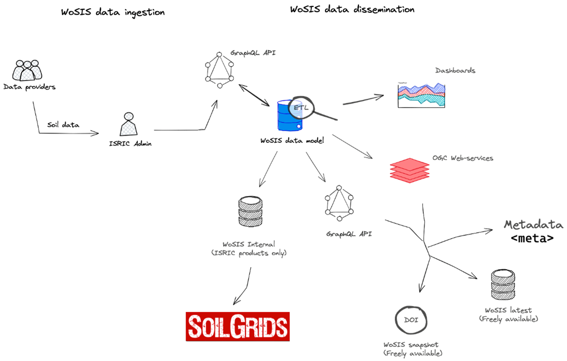
Schematic WoSIS workflow for ingesting, standardising and disseminating soil profile (point) data
What is "WoSIS"?
WoSISTM stands for 'World Soil Information Service', a large database based on PostgreSQL + API's, workflows, dashboards etc., developed and maintained by ISRIC, WDC-Soils. It provides a growing range of quality-assessed and standardised soil profile data for the world. For this, it draws on voluntary contributions of data holders/providers worldwide who are willing to share their data for the greater benefit of the international community.
The source data come from different types of surveys ranging from systematic soil surveys (i.e., full profile descriptions) to soil fertility surveys (i.e., mainly top 20 to 30 cm). Further, depending on the nature of the original surveys the range of soil properties can vary greatly.
The quality-assessed and standardised data are made available freely to the international community through several webservices, this in compliance with the conditions specified by the various data providers.
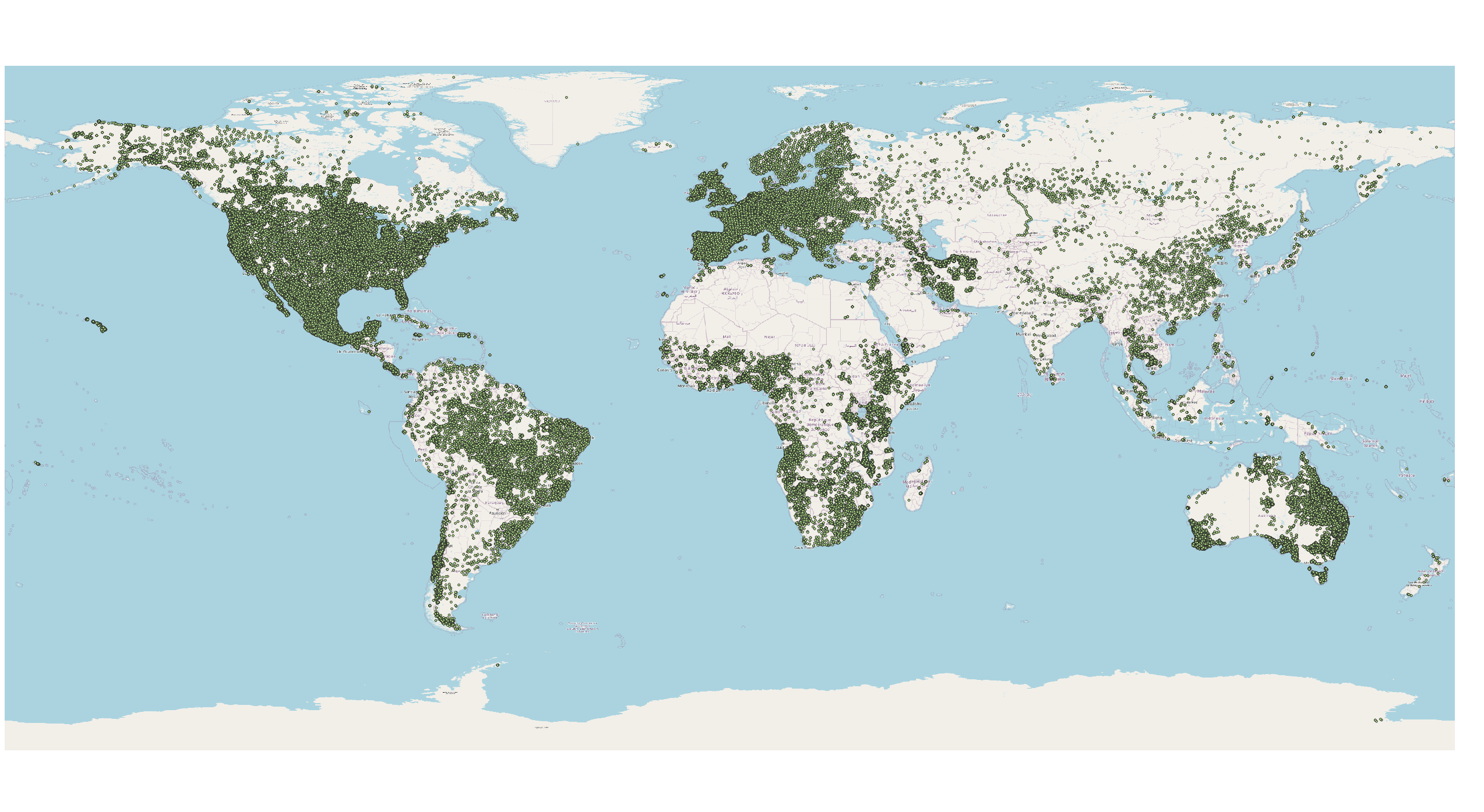
Location of soil profiles provided with WoSIS latest (see also dashboard)
Which soil properties are standardised?
We presently standardise and serve the following soil chemical properties (organic carbon, total carbon, total carbonate equivalent, total nitrogen, phosphorus (extractable-P, total-P, and P-retention), soil pH, cation exchange capacity, and electrical conductivity) and physical properties (soil texture (sand, silt, and clay), bulk density, coarse fragments, and water retention), grouped according to analytical procedures (aggregates) that are operationally comparable. As far as specified by the data providers, additional information is provided on the analytical methods themselves (e.g. class size limits for soil textural fractions or the fine earth fraction; methods (e.g. pipette or hydrometer) as well as dispersion agents) under method options. Further, for each profile, we provide the original soil classification (FAO, WRB, USDA, and version) and horizon designations as far as these have been specified in the source databases.
From mid 2025 onwards, we will consider/process a wider range of soil properties including micronutrients, trace metal elements, soluble salts, and hydraulic conductivity in the ETL process, see Batjes (2025) for details.
See below for attribute coding.
Towards soil data harmonisation
"Harmonization could be seen as a next step to standardization, where parties agree to apply a standard as the central concept to which soil data and information are translated" (GSP, 2014). Full data harmonization in a global context, the ultimate goal of WoSIS, is a daunting task. It will first become feasible once results of extensive, comparative proficiency testing programmes become available, for example in the framework of Pillar 5 of the Global Soil Partnership and GLOSOLAN (Global Soil Laboratory Network), and a common set of ’international’ reference methods Y , where Y is a defined standard operating procedure (SOP, for example ISO-SOP, GLOSOLAN-SOP or ICPF-SOP), has been accepted and endorsed by the international soil community.
Once available for specified soil types or soil landscapes, such pedotransfer functions can be applied to the standardised data provided by WoSIS. The resulting data sets, with associated measures for uncertainty, should be stored as separate datasets of soil properties 'harmonised as if measured according to method Y.' It should be noted, however, that decisions as to whether full harmonization is necessary for mapping a given soil property can be influenced by the resolution of the mapping itself as well as the desired precision and accuracy of the predictions. For a broader discussion see Batjes (2023).
What do the attribute codes mean?
The complement of soil properties provided in wosis_latest is presented in the table below. When specified in the source meta data, 'aggregated' information on the analytical procedures is provided with the standardised data; this encompasses generalisations considered commensurate with broad scale applications (see Batjes 2025).
| Code | Property and procedure | Units | Description |
|---|---|---|---|
| BDFI33 | Bulk density fine earth - 33 kPa | kg/dm³ | Bulk density of the fine earth fraction a, equilibrated at 33 kPa |
| BDFIAD | Bulk density fine earth - air dry | kg/dm³ | Bulk density of the fine earth fraction, air dried |
| BDFIFM | Bulk density fine earth - field moist | kg/dm³ | Bulk density of the fine earth fraction, field moist |
| BDFIOD | Bulk density fine earth - oven dry | kg/dm³ | Bulk density of the fine earth fraction, oven dry |
| BDWSAD c | Bulk density whole soil - air dry | kg/dm³ | Bulk density of the whole soil including coarse fragments, air dried |
| BDWSFM c | Bulk density whole soil - field moist | kg/dm³ | Bulk density of the whole soil including coarse fragments, field moist |
| BDWSOD | Bulk density whole soil - oven dry | kg/dm³ | Bulk density of the whole soil including coarse fragments, oven dry |
| TCEQ | Calcium carbonate equivalent total | g/kg | The content of carbonate in a liming material or calcareous soil calculated as if all of the carbonate is in the form of CaCO3 (in the fine earth fraction); also known as inorganic carbon |
| ORGM | Organic matter | g/kg | Gravimetric content of organic matter (LOI) carbon in the fine earth fraction |
| ORGC | Organic carbon | g/kg | Gravimetric content of organic carbon in the fine earth fraction |
| TOTC | Total carbon | g/kg | Gravimetric content of organic carbon and inorganic carbon in the fine earth fraction |
| NITKJD | Total nitrogen (N) | g/kg | The sum of total nitrogen measured according to Kjeldahl and Dumas method |
| CECPH7 | Cation exchange capacity - buffered at pH7 | cmol(c)/kg | Capacity of the fine earth fraction to hold exchangeable cations, estimated by buffering the soil at 'pH7' |
| CECPH8 | Cation exchange capacity - buffered at pH8 | cmol(c)/kg | Capacity of the fine earth fraction to hold exchangeable cations, estimated by buffering the soil at 'pH8' |
| ECEC | Effective cation exchange capacity | cmol(c)/kg | Capacity of the fine earth fraction to hold exchangeable cations at the pH of the soil (ECEC). Conventionally approximated by summation of exchangeable bases (Ca2+, Mg2+, K+, and Na+) plus 1 N KCl exchangeable acidity (Al3+ and H+) in acidic soils |
| ELCO20 | Electrical conductivity - ratio 1:2 | dS/m | Ability of a 1:2 soil water extract to conduct electrical current |
| ELCO25 | Electrical conductivity - ratio 1:2.5 | dS/m | Ability of a 1:2.5 soil water extract to conduct electrical current |
| ELCO50 | Electrical conductivity - ratio 1:5 | dS/m | Ability of a 1:5 soil water extract to conduct electrical current |
| ELCOSP | Electrical conductivity - saturated paste | dS/m | Ability of a water saturated soil paste to conduct electrical current (ECe) |
| CFGR | Coarse fragments gravimetric total | g/100g | Gravimetric content of coarse fragments in the whole soil |
| CFVO | Coarse fragments volumetric total | cm³/100cm³ | Volumetric content of coarse fragments in the whole soil |
| CLAY | Clay total | g/100g | Gravimetric content of < X mm soil material in the fine earth fraction (e.g. X = 0.002 mm as specified in the analytical method description) |
| SILTe | Silt total | g/100g | X to Y mm fraction of the fine earth fraction; Y as specified in the analytical method description (e.g. Y = 0.05 mm) |
| SAND | Sand total | g/100g | Larger than Y mm fraction of the fine earth fraction; Y as specified in the analytical method description (e.g. Y = 0.05 mm to 2 mm) |
| PHBA c | pH BaCl2 | - | A measure of the acidity or alkalinity in soils, defined as the negative logarithm (base 10) of the activity of hydronium ions (H+) in a BaCl2 solution |
| PHCA | pH CaCl2 | - | A measure of the acidity or alkalinity in soils, defined as the negative logarithm (base 10) of the activity of hydronium ions (H+) in a CaCl2 solution, as specified in the analytical method descriptions |
| PHAQ | pH H2O | - | A measure of the acidity or alkalinity in soils, defined as the negative logarithm (base 10) of the activity of hydronium ions (H+) in water |
| PHKC | pH KCl | - | A measure of the acidity or alkalinity in soils, defined as the negative logarithm (base 10) of the activity of hydronium ions (H+) in a KCl solution, as specified in the analytical method descriptions |
| PHNF | pH NaF | - | A measure of the acidity or alkalinity in soils, defined as the negative logarithm (base 10) of the activity of hydronium ions (H+) in a NaF solution, as specified in the analytical method descriptions |
|
PHETB1 d [PHPBY] |
Phosphorus (P) - Bray I | mg/kg | Measured according to the Bray-I method, a combination of HCl and NH4 F to remove easily acid soluble P forms, largely Al- and Fe-phosphates (for acid soils) |
|
PHETM3 d [PHPMH3] |
Phosphorus (P) - Mehlich 3 | mg/kg | Measured according to the Mehlich-3 extractant, a combination of acids (acetic [HOAc] and nitric [HNO3]), salts (ammonium fluoride [NH4F] and ammonium nitrate [NH4 NO3]), and the chelating agent ethylenediaminetetraacetic acid (EDTA); considered suitable for removing P and other elements in acid and neutral soils |
|
PHETOL d [PHPOLS] |
Phosphorus (P) - Olsen | mg/kg | Measured according to the P-Olsen method: 0.5 M sodium bicarbonate (NaHCO3) solution at a pH of 8.5 to extract P from calcareous, alkaline, and neutral soils |
| PHPRTN | Phosphorus (P) - retention | mg/kg | Retention measured according to the New Zealand method |
| PHPTOT | Phosphorus (P) - total | mg/kg | Determined with a very strong acid (aqua regia and sulfuric acid/nitric acid) |
| PHPWSL | Phosphorus (P) - water soluble | mg/kg | Measured in 1:x soil:water solution (mainly determines P in dissolved forms) |
| WG1500 | Water retention gravimetric - 1500 kPa | g/100g | Soil moisture content by weight, at tension 1500 kPa |
| WG0500 | Water retention gravimetric - 500 kPa | g/100g | Soil moisture content by weight, at tension 500 kPa |
| WG0200 | Water retention gravimetric - 200 kPa | g/100g | Soil moisture content by weight, at tension 200 kPa |
| WG0100 | Water retention gravimetric - 100 kPa | g/100g | Soil moisture content by weight, at tension 100 kPa |
| WG0033 | Water retention gravimetric - 33 kPa | g/100g | Soil moisture content by weight, at tension 33 kPa |
| WG0010 | Water retention gravimetric - 10 kPa | g/100g | Soil moisture content by weight, at tension 10 kPa |
| WG0006 | Water retention gravimetric - 6 kPa | g/100g | Soil moisture content by weight, at tension 6 kPa |
| WV1500 | Water retention volumetric - 1500 kPa | cm³/100cm³ | Soil moisture content by volume, at tension 1500 kPa |
| WV0500 | Water retention volumetric - 500 kPa | cm³/100cm³ | Soil moisture content by volume, at tension 500 kPa |
| WV0200 c | Water retention volumetric - 200 kPa | cm³/100cm³ | Soil moisture content by volume, at tension 200 kPa |
| WV0100 | Water retention volumetric - 100 kPa | cm³/100cm³ | Soil moisture content by volume, at tension 100 kPa |
| WV0033 | Water retention volumetric - 33 kPa | cm³/100cm³ | Soil moisture content by volume, at tension 33 kPa |
| WV0010 | Water retention volumetric - 10 kPa | cm³/100cm³ | Soil moisture content by volume, at tension 10 kPa |
| WV0006 c | Water retention volumetric - 6 kPa | cm³/100cm³ | Soil moisture content by volume, at tension 6 kPa |
| CFAO | Soil classification FAO | Classification of the soil profile according to specified edition (year) of the FAO-Unesco Legend (up to soil unit level) | |
| CWRB | Soil classification WRB | Classification of the soil profile according to specified edition (year) of the World Reference Base for Soil Resources (WRB, up to qualifier level) | |
| CSTX | Soil classification Soil Taxonomy | Classification of the soil profile according to specified edition (year) of the USDA Soil Taxonomy (up to subgroup level) | |
| DSDS | Depth of soil - sampled | cm | Total depth of soil sampled |
| HODS | Horizon designation | Horizon designation as provided in the source database b |
Notes:
a The fine earth fraction is generally defined as being < 2 mm. However, an upper limit of 1 mm was used in the former Soviet Union and its satellite states (Katchynsky scheme). This has been indicated in the database, see here.
b Where available, the 'cleaned' (original) layer/horizon designation is provided for general information; these codes have not been standardised. When horizon designations are not provided in the source data bases, we have flagged all layers with an upper depth given as being negative (e.g. -10 to 0 cm that is using pre-1993 conventions; see WoSIS Procedures Manual 2018, p. 24, footnote 9) in the source databases as being 'litter' layers (i.e. organic layers at the surface of a mineral soil).
c Please note that there are still very few observations for several soil properties (e.g., WV0006 and PHBA), and these are not being served yet.
d The following CODEs, for extractable-P methods, have been changed in the 2022 version of wosis_latest. The 'old' names are given between brackets in the table, e.g. [PHPMH3] .
e The upper and lower limits for the 'silt' size fraction can vary markedly between countries (see here). Development and application of conversion or harmonisation procedures to a common 'silt' fraction (e.g. 0.002-0.05mm) are beyond the remit of the WoSIS project itself. The required pedotransfer functions should be developed (and tested) prior to generating particle size class related soil property maps for a given geography. Research in this direction is being undertaken by the SoilGrids team, using 'best available' comparative datasets for calibration. However, when only three particle size classes are known for each classification system (i.e. dataset), such transformations are likely to yield only a rough "approximation of what would be obtained with laboratory experiments" (Moeys, 2024) and other solutions (e.g. Padarian et al, 2012, Corral-Pazos-de-Provens et al. 2022) may be needed .
What measures for fitness for intended use are provided?
Soil data are fraught with uncertainty. Therefore, we provide three measures for 'fitness-for-intended-use' of the standardised soil profile (point) data:
- Positional uncertainty.
- Attribute accuracy (variability, expressed as coefficient of variation).
- Age of data (date the profiles were described/sampled).
The above measures should be considered carefully during digital soil mapping so to assess the uncertainty attached to the predictive maps and any interpretations derived from them. Further, especially at (sub)national level, differences in method options should be taken into account. Importantly, it is up to the users themselves to carefully assess if they need to convert part of the standardised data served from WoSIS to 'make them fit' for their intended applications.
As an example, for some studies texture data for selected countries may still need to be converted to a specific set of 'reference' particle size class limits using pedotransfer functions. In that case, the 'silt size' fraction determined according to ASRIS/IS conventions (0.002 to 0.020 mm), for example, would have to be converted to the USDA convention (0.002 to 0.050 mm) respectively WRB convention (0.002 to 0.063 mm), prior to using them for global mapping purposes.
How can I access data derived from WoSIS?
Standardised profile data (with 'public' licenses, i.e. CC-BY or CC-BY-NC) derived from WoSIS are distributed in two ways. The most recent, latest (dynamic) version can be accessed through an OGC-compliant WFS (Web Feature Service). Further, snapshot (static) dataset(s) in TSV (tab separated values) format with a DOI are provided for consistent citation purposes.
The most recent WoSIS release can be accessed through the following services:
- WoSIS_latest: This dynamic dataset contains the most recent complement of standardised soil data served from WoSIS. Being dynamic, this dataset will grow once new point data are acquired and standardised, additional soil properties are considered, and/or when possible amendments are required.
The data can be accessed through an OGC-compliant WFS (Web Feature Service); for this, enter the following WFS link (http://maps.isric.org/mapserv?map=/map/wosis_latest.map) directly in your GIS application.
For an overview of layers served, please go to the ISRIC Soil Data Hub. Alternatively, for a generalised overview see the wosis_latest dashboard, or use the GraphQL API to easily query the data (see below under Tutorials). - Snapshots: These static datasets, in TSV format, are a representation of the complement of standardised data available at a given moment. Each snapshot is given a unique name and digital object identifier (DOI) for consistent citation purposes. The latest snapshot is: "December 2023'. Generally, a new snapshot will be prepared when some 40,000-80,000 new profiles have been shared with us for standardisation and/or the range of soil properties standardised has increased substantially. The next snapshot release is foreseen in mid 2026.
- Webplatform: Allows to view, query/explore and download WoSIS-latest point data (as well as SoilGrids layers, version 2020).
Are there any tutorials?
The following tutorials are available:
- How to import 'wosis_snapshot_2023' tsv files into R, see tutorial.
- How to import 'wosis_snapshot_2023' tsv files into Excel, see tutorial.
- Accessing 'wosis_latest' from QGIS, see tutorial.
- Accessing 'wosis_latest' from R, see tutorial.
- Querying/exploring 'wosis_latest' using GraphQL API, see tutorial.

What is the WoSIS data sharing policy?
Standardised data served through 'wosis_latest' respectively the snapshots are freely accessible to the international community subject to proper acknowledgement. The data license specified (by the various source data providers (i.e., CC-BY or CC-BY-NC) themselves should be respected when using the data
Some source datasets have been shared with ISRIC with a more restrictive CC-license; we can standardise these data but are not allowed to share them freely with the international community. The later 'restricted' data sets only be used by ISRIC for SoilGrids applications/visualisations; the resulting GIS layers, however, are freely available to the international community (see FAQ - SoilGrids).
WoSIS-derived data are provided to users under the general terms and conditions of the ISRIC software and data policy.
Overall, we cannot redistribute any of the source data shared for consideration in WoSIS.
How can I help improve WoSIS?
There are still many gaps in WoSIS. If you wish to share soil profile data for consideration/processing in WoSIS please do contact us. See here for additional information.
Importantly, we strongly encourage all data providers to assign a DOI (Digital Object Identifier) to their unique dataset before submission.
We particularly welcome datasets that also include duplicate measurements so that we may refine our procedures for quantifying the uncertainty in wet chemistry data (see Van Leeuwen et al. 2020, 2024), and ultimately in soil data derived from spectrometry, in WoSIS.
Who shared soil profile data for inclusion in WoSIS?
WoSIS draws on a large collection of geo-referenced soil profile data for the world. Populating WoSIS has been made possible thanks to the contributions and shared knowledge of a steadily growing number of data providers. We are grateful for their contributions (see acknowledgments).
Who contributed to the development of the WoSIS database?
The development of WoSIS started in 2009 as part of an institutional strategy for re-design of ISRIC’s IT strategy. Since that time, many individuals have contributed to the development of the WoSIS data model in an iterative process.
Future developments
Data acquisition
There are still numerous gaps in WoSIS in terms of geographic distribution as well as the range of soil taxonomic units and/or soil properties represented. We aspire to address such gaps in future updates of wosis_latest, resp. new snapshots. ISRIC are however largely dependent on the ability and willingness of soil data owners to share some of their data freely for the greater benefit of the international community.
ETL development
To facilitate and stimulate data sharing, we are developing a web-based facility (front-end) to permit data providers to directly upload their soil data to WoSIS in a consistent format based on the refactored ETL API procedures. As an incentive, upon their standardisation, we aim to provide each data provider with a tailor-made dashboard for viewing and querying the datasets they shared, possibly with a DOI to facilitate citation. For additional information see here.
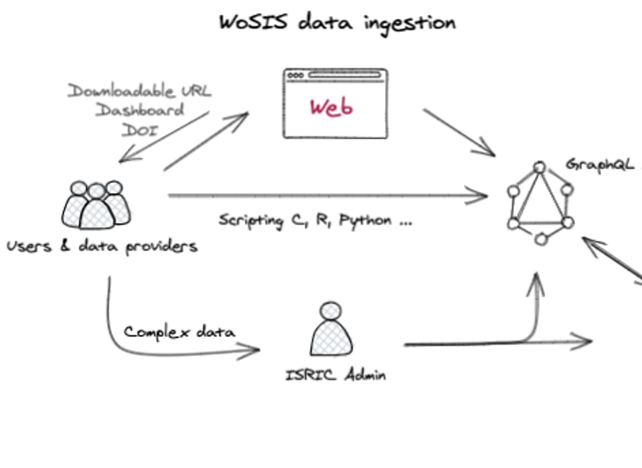
Future web-based ETL facility for uploading data to WoSIS
Expanded set of soil properties:
Procedures for standardising a wider range of chemical soil properties are being developed. These properties include: Calcium (Ca), Magnesium (Mg), Potassium (K), Sodium (Na), Aluminum (Al), Hydrogen (H), Acidity (Al3+ + H+), Arsenicum (As), Boron (Bo), Bromine (Br), Cadmium (Cd), Copper (Cu), Iron (Fe), Lead (Pb), Manganese (Mn), Molybdenum (Mo), Nickel (Ni), Selenium (Se), Zinc (Zn), as well as soluble salts (anions and cations) for saline soils.
Recommended laboratory procedures and method options for these properties were identified through a literature survey and documented in a revised Procedures Manual. The resulting information is now being included in the evolving, web-based ETL facility. Once there are "enough" data (e.g. > 30,000 observations) for a given combination of "property-procedure-method option" (e.g, Zn, extraction, Mehlich3), a new dataset will be served through wosis_latest (probably, not before Q4-2026).
How should the WoSIS datasets be cited?
We serve both static snapshots as well a dynamic version of the WoSIS-derived soil properties for the world.
Where data represent a substantial contribution to a scientific paper, formal inclusion of the WoSIS-developers as co-author(s,) in accordance with scientific practice, would be appropriate.
Required citations are as follows:
a) Snapshots should be cited in accord with the DOI of the accompanying data paper, for example.:
- Batjes NH, Calisto L and de Sousa LM, 2024. Providing quality-assessed and standardised soil data to support global mapping and modelling (WoSIS snapshot 2023). Earth Syst. Sci. Data https://doi.org/10.5194/essd-16-4735-2024
b) Wosis_latest layers should be cited in accord with the following examples:
- For whole 'wosis-latest' dataset:
Batjes NH, Calisto L and de Sousa LM, 2024. WoSIS-latest: Standardised world soil profile data. ISRIC Soil Data Hub resource identifier: https://tinyurl.com/39xhaa9d. Date downloaded: 15/01/2024. - For individual datasets (please adapt per dataset):
Batjes NH, Calisto L and de Sousa LM, 2024. WoSIS latest - Water retention volumetric - 500 kPa. ISRIC Soil Data Hub resource identifier: 2f99e11b-183c-11e9-aba8-a0481ca9e724. Date downloaded: 15/01/2024.
What if I did not find an answer to my question?
If you have a technical question about WoSIS that is not addressed in this FAQ, please post it to our 'Google group'. For this, please register first at WoSIS user group. ISRIC staff will be automatically notified of any new questions arising. Using the group will make it easier for other WoSIS-users to find quality answers to their questions.
Alternatively, should you have a technical question about SoilGrids (i.e., digital soil property maps) please post your question GIS.StackExchange under the tag soilgrids.
Acknowledgements
WoSIS is funded from ISRIC's core funding (Netherlands Government). Between 2021-2025 it received co-funding from the HoliSoils project (EU Horizon Grant Agreement ID 101000289).
A wide range of agencies and experts have provided data for the WoSIS effort; we gratefully thank them for their contributions.
Main references
- Batjes NH (2025). World Soil Information Service (WoSIS) -- Procedures for coding and standardizing soil analytical method descriptions, ISRIC - World Soil Information, Wageningen, 51 p. https://doi.org/10.17027/isric-wdcsoils-1nh7-zr51.
- Batjes NH, Calisto L, and de Sousa, LM (2024). Standardised soil profile data to support global mapping and modelling (WoSIS snapshot 2023). Earth System Science Data https://doi.org/10.5194/essd-16-4735-2024 [snapshot 3]
- Batjes NH (2023). Options for harmonising soil data obtained from different sources. ISRIC - World Soil Information, Wageningen, 20 pp. doi: 10.17027/isric-wdc-6ztd-eb19
- Batjes NH and van Oostrum AJM (2023). World Soil Information Service (WoSIS). Procedures for standardizing soil analytical method descriptions. ISRIC - World Soil Information, Wageningen, 46 p. https://doi.org/10.17027/isric-1dq0-1m83 [Superseded by this document]
- Batjes NH, Ribeiro E, and van Oostrum Ad (2020). Standardised soil profile data to support global mapping and modelling (WoSIS snapshot 2019). Earth System Science Data,12, 299–320. doi: 10.5194/essd-12-299-2020 [snapshot 2]
- Batjes NH, Ribeiro E, van Oostrum A, Leenaars J, Hengl T and Mendes de Jesus J (2017). WoSIS: providing standardised soil profile data for the world. Earth Syst. Sci. Data 9, 1-14. doi:10.5194/essd-9-1-2017 [snapshot 1]
- Calisto L (2023). ISRIC GraphQL web services for WoSIS and ISIS data access, ISRIC - World Soil Information. https://graphql.isric.org/
- Calisto L, de Sousa LM and Batjes NH (2023). Standardised soil profile data for the world (WoSIS snapshot – December 2023), https://doi.org/10.17027/isric-wdcsoils-20231130
- De Sousa, LM (2023). WoSIS Data Model 2023. Procedures Manual - Technical Documentation. https://git.wur.nl/isric/databases/wosis-docs/-/blob/main/README.md
- Ribeiro E, Batjes NH and van Oostrum AJM (2020). World Soil Information Service (WoSIS) - Towards the standardization and harmonization of world soil data. Procedures Manual 2020. ISRIC Report 2020/01, ISRIC - World Soil Information, Wageningen, 166 p. doi: 10.17027/isric-wdcsoils.202001
[Note: The WoSIS data model was updated to the ISO 28258 domain model in 2023 hence parts of the PM2020 are now outdated, see de Sousa (2023) above] - van Leeuwen CCE, Mulder VL, Batjes NH and Heuvelink GBM (2021). Statistical modelling of measurement error in wet chemistry soil data. European Journal of Soil Science, doi: 10.1111/ejss.13137
- van Leeuwen CCE, Mulder VL, Batjes NH and Heuvelink GBM (2024). Effect of measurement error in wet chemistry soil data on the calibration and model performance of pedotransfer functions. Geoderma 442, 116762. https://doi.org/10.1016/j.geoderma.2023.116762