Background
Soil degradation is a global issue. Soil protection and rehabilitation of degraded areas safeguard the natural resource of agricultural production, which secures income, food supplies, and reduces poverty and hunger in rural areas.
Through its ONEWORLD-No Hunger special initiative, Germany’s Federal Ministry for Economic Cooperation and Development (BMZ) has made significant investments in soil protection and rehabilitation for food security (ProSoil) as well as adaptation to climate change and co-benefits with carbon sequestration.
As part of this initiative, the World Overview of Conservation Approaches and Technologies (WOCAT) Consortium partner GIZ implemented the ProSoil program. ProSoil aims to help smallholder farmers learn how to apply climate-friendly, agroecological methods to protect their land from erosion and restore and maintain soil fertility. To this end, WOCAT has supported the documentation and exchange of best practices in the seven ProSoil program countries: Benin, Burkina Faso, Ethiopia, India, Kenya, Madagascar, and Tunisia. The WOCAT consortium proposed the project ‘Knowledge Management and Decision Support in Soil Protection and Rehabilitation Initiatives’.
Goal
The project’s primary objective was to support knowledge management and decision support for soil protection and rehabilitation by strengthening partners in standardised documentation of sustainable land management good practices, sustainable land management knowledge sharing and mainstreaming to facilitate wide scaling out of good sustainable land management solutions.
Objectives
The above goal was translated into three objectives:
- Sustainable land management (SLM) good practices in countries of the “ONEWORLD - No Hunger” initiative documented and shared in a standardized format;
- National SLM compilations produced and presented in view of mainstreaming and scaling out at national or sub-national levels;
- Countries trained in land degradation (LD)/SLM mapping tools and land degradation neutrality (LDN) mapping implemented
ISRIC contributed to the above objectives with the following activities:
Main activities
- Producing national soil type and property maps of ProSoil countries and project areas.
- Organising online webinars on WOCAT-GEE LD/SLM mapping tools and approaches
- Mapping soil properties and spatial distribution of the documented WOCAT QT/QA for the partner countries
- Training on WOCAT LD/SLM Mapping Tools (QM) and LDN mapping and monitoring using Google Earth Engine (GEE) platform
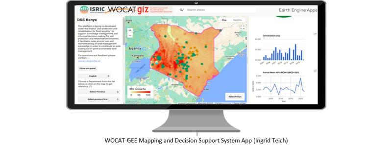
- Developing LDN decision support system - apps for Benin, Ethiopia and Kenya
- Developing road maps for application of LD/SLM mapping tools for Benin, India and Kenya and partially implementing activities in the road maps.
Results
- A series of soil maps for Benin, Burkino Faso, Ethiopia, India, Kenya, Madagascar, Tunisia and spatial distribution of the documented WOCAT QT/QA for the partner countries
- Implementation of a first round of activities in the roadmaps for Benin, India and Kenya
- Final report .
Consortium
WOCAT secretariat at the Centre for Development and Environment (CDE), University of Bern, Switzerland, was the overall project leader. Alliance Biodiversity International-CIAT, Ethiopia, and ISRIC–World Soil Information, The Netherlands were the implementing partners.
Funding
The project was funded by the Germany’s Federal Ministry for Economic Cooperation and Development (BMZ), and implemented by the German Agency for International Cooperation (GIZ).