WoSIS Soil Profile Database
The World Soil Information Service (WoSIS) aims to serve the user with a selection of standardised and ultimately harmonised soil profile data. The quality-assessed data may be used to underpin digital soil mapping and a range of global assessments. WoSIS is an important building block of ISRIC’s evolving, searchable data infrastructure.
Aims
The aims of the World Soil Information Service are to:
- Safeguard world soil profile data 'as is' (especially for soil legacy data)
- Quality assess and standardise the 'shared' soil data
- Provide the standardised data for digital soil mapping and a range of environmental applications (in accordance with the licenses indicated by each data provider).
General workflow
All data submitted for consideration in WoSIS are first preserved ‘as is’ in the ISRIC WDC-Soils Data Repository with the accompanying licenses. Subsequently, in accordance with the license, they are quality-assessed (i.e., plausibility checks), standardised, imported into the WoSIS data model itself and, where possible, harmonised using consistent procedures (Fig. 1).
We presently consider the following soil chemical properties (organic carbon, total carbon, total carbonate equivalent, total nitrogen, phosphorus (extractable-P, total-P, and P-retention), soil pH, cation exchange capacity, and electrical conductivity) and physical properties (soil texture (sand, silt, and clay), bulk density, coarse fragments, and water retention), grouped according to analytical procedures (aggregates) that are operationally comparable. Further, for each profile, we provide the original soil classification (FAO, WRB, USDA, and version) and horizon designations insofar as these have been specified in the source databases.
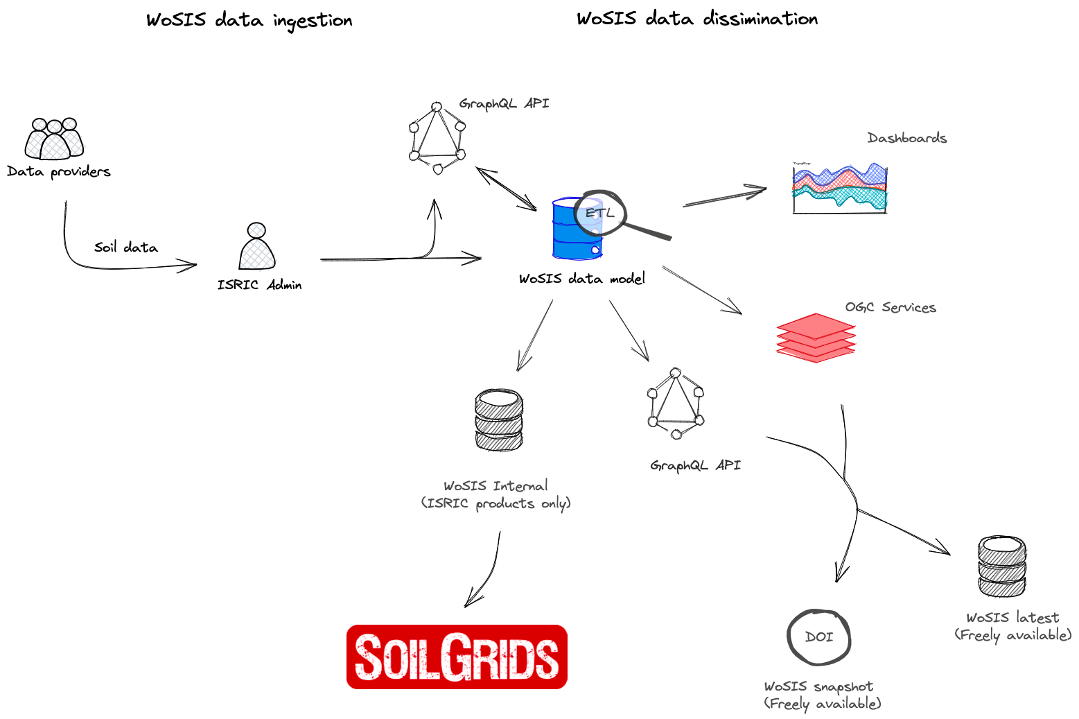
Figure 1. WoSIS workflow for ingesting, processing and disseminating data.
Measures for 'fitness-for-use'
Soil profile data that underpin WoSIS were derived from a wide range of sources. Three measures for 'fitness-for-intended-use' of the data are presented:
- positional uncertainty (i.e., location of a profile's site)
- a first approximation for the uncertainty associated with the operationally defined analytical methods
- date of sampling.
These measures are provided for possible consideration in digital soil mapping and subsequent earth system modelling.
Further, when specified by the data providers, additional information is provided on the analytical methods themselves (e.g. class size limits for soil textural fractions or the fine earth fraction, see documentation). This extra information provides the basis for eventual harmonisation, the ultimate long-term goal of WoSIS.
Serving standardised data
Some 228,000 geo-referenced, standardised point data are currently served from WoSIS via WFS (Fig. 2). This corresponds with more than 6 million soil records. The number of measured data for each property varies between profiles and with depth, generally depending on the purpose of the initial studies. Further, in most source data sets, there are fewer data for soil physical as opposed to soil chemical attributes. There also are fewer measurements for deeper than for surficial horizons. Generally, limited quality information is associated with the various source data.
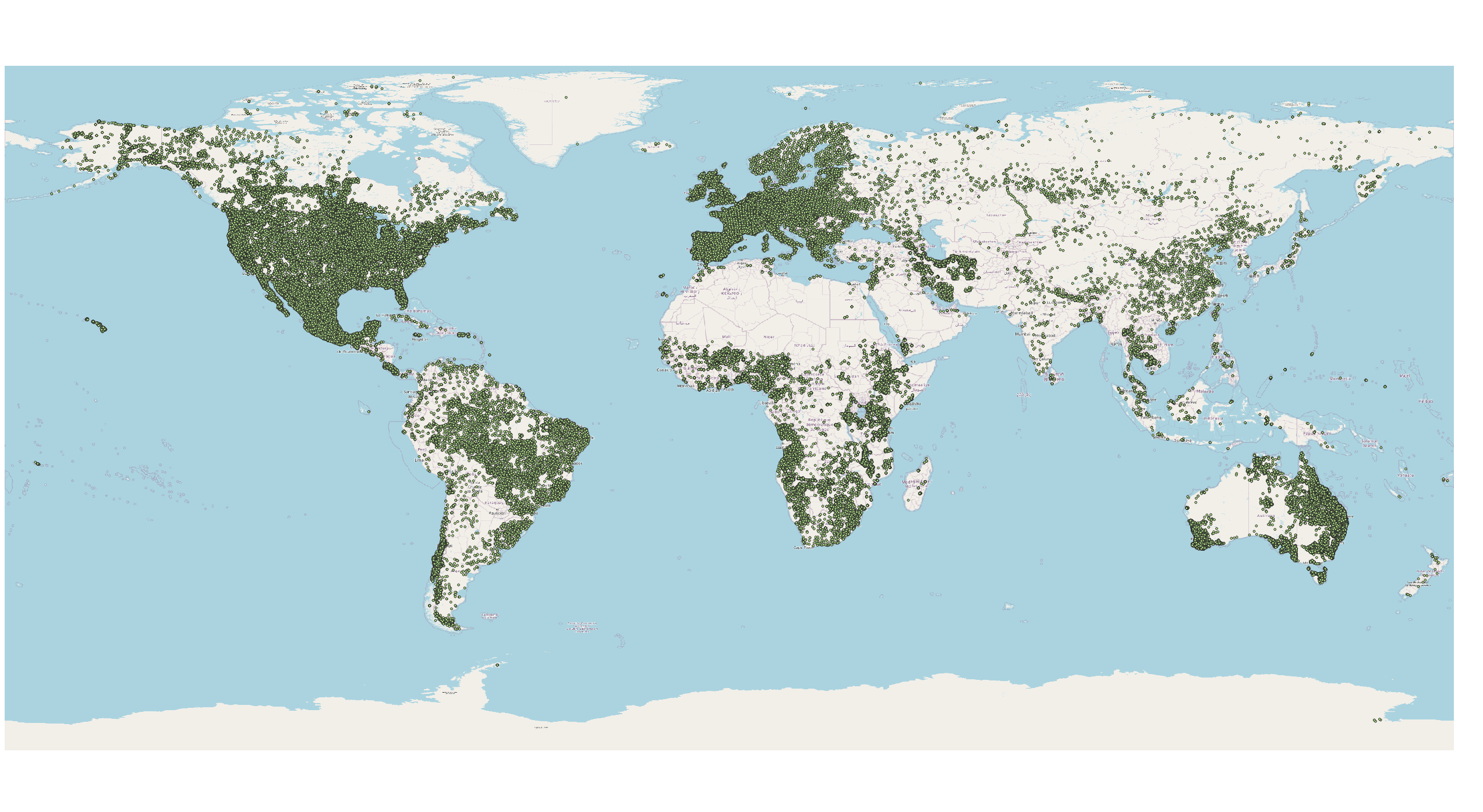
Figure 2. Location of soil profiles provided with WoSIS latest (see also dashboard)
Unfortunately, we can not distribute standardised data for some extra 110,000 "shared" profiles in view of "restrictive" license agreements with some data providers. Positively, however, ISRIC WDC-Soils can use the full complement of standardised data to underpin SoilGrids applications, which are made available CC-BY to the international community.
Full data harmonization in a global context, the ultimate objective, is a daunting task. It will first become feasible once results of extensive, comparative proficiency testing programmes become available, for example in the framework of Pillar 5 of the Global Soil Partnership and GLOSOLAN (Global Soil Laboratory Network), and a common set of ’international’ reference methods (e.g. ISO procedures or SOP’s developed by GLOSOLAN) has been accepted by the international soil community. For further information read here.
Data download and visualisation
Data served from WoSIS are supplied in compliance with the license specified by each data provider.
The standardised data can be accessed here.
For a quick visualisation of point data served with wosis_latest click dashboard.
Tutorials
- Accessing 'wosis_latest' from QGIS, see tutorial.
- Accessing 'wosis-latest' from R, see tutorial.
- Querying/exploring 'wosis_latest' using GraphQL API, see tutorial.
Applications
An important application of the WoSIS-standardised data at ISRIC, in collaboration with partners, is the generation of soil property maps for the world using digital soil mapping (see SoilGrids) and other products derived from advanced data processing (e.g., aps, visualizations). The resulting products are freely available to the international community through ISRIC's Soil Data Hub.
Sharing data to support global modelling
If you wish to share soil profile data for consideration/processing in WoSIS please see here. We particularly welcome datasets that also include duplicate measurements so that we may refine our procedures for quantifying the uncertainty in wet chemistry data (see Van Leeuwen et al. 2020), and ultimately in soil data derived from spectrometry, in WoSIS.
Technical documentation and data papers
- Batjes, NH, Calisto L and de Sousa LM, 2024. Providing quality-assessed and standardised soil data to support global mapping and modelling (WoSIS snapshot 2023). Earth Syst. Sci. Data, 16(10): 4735-4765 https://doi.org/10.5194/essd-16-4735-2024.
- Batjes NH, Ribeiro E and van Oostrum AJM, 2020. Standardised soil profile data to support global mapping and modelling (WoSIS snapshot 2019). Earth System Science Data, 12(1):299-320 https://doi.org/10.5194/essd-12-299-2020.
- Batjes NH, Ribeiro E and van Oostrum AJM 2019. Standardised soil profile data for the world (WoSIS snapshot - September 2019). ISRIC WDC-Soils (dataset).
- Ribeiro E, Batjes NH and van Oostrum AJM 2020. World Soil Information Service (WoSIS) - Towards the standardization and harmonization of world soil data. Procedures Manual 2020. ISRIC report 2020/01, ISRIC - World Soil Information, Wageningen, 166 p. (report; superceded).
- Batjes, NH, 2023. Options for harmonising soil data obtained from different sources. ISRIC – World Soil Information, Wageningen., 20 p. (report)
- Batjes NH and van Oostrum AJM, 2023. WoSIS Procedures for standardizing soil analytical method descriptions, ISRIC - World Soil Information, Wageningen, 46 p. https://doi.org/10.17027/isric-1dq0-1m83
![]()