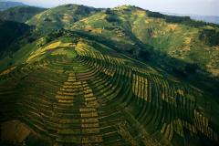
to better serve the Land and Earth System Modelling community that typically works at coarser resolution than 250 meters (m), ISRIC released an aggregated SoilGrids product at resolutions of 1000 m and 5000 m. The mean predictions were aggregated at the corresponding coarser resolution.
On Tuesday, 25 January a new project, Land Soil Crop Information Services (LSC Hubs), to support climate-smart agriculture in Ethiopia, Kenya and Rwanda held its public launch event online.
A new open-access field work tool for soil description is now available through ISRIC – World Soil Information: Soil Description DevTool. This tool is for people doing field work who will describe soils using the United Nations’ Food and Agriculture Organization (FAO) 2006 Guidelines for Soil Description.
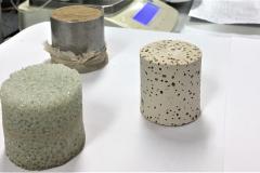
ISRIC guest researcher Ad van Oostrum together with Gerben Bakker of Wageningen Environmental Research, presented results from a joint research project on designing porous reference samples for calibrating water retention curve measurements.
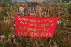
ISRIC World Soil Museum welcomes an artist-in-residence to bring new perspectives to education about the importance and diversity of soils. The artist, Kate Foster, will work with the World Soil Museum during 2022 to generate dialogue and engagement around peatland and wetland soils.
For 55 years, ISRIC – World Soil Information has worked together with many international partners to achieve sustainable use of soil, one of our most precious global resources. Take a journey with us back in time to explore where five and a half decades of soil information service work has led.
Celebrate World Soil Day 2021 with the Global Soil Museum Network by virtually visiting four soil museums around the world and learning about soil science and this year's theme: "Halt soil salinization, boost soil productivity."
ISRIC – World Soil Information guest researcher David G. Rossiter recently published “Are soil phenoforms the new normal? Soil classification and soil mapping in the Anthropocene” in the journal Soil Security.
The FOSS4G conference is an annual global conference around Open Source Geospatial software. ISRIC – World Soil Information is an active participant in various open source communities, which shared their current and upcoming activities at the conference. This post highlights some of the presentations and contains links to the videos.
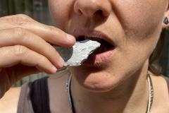
From 1 November until 17 December a new exhibit, Earth as Superfood, showcasing edible soils from around the world begins in two locations on Wageningen University and Research (WUR) campus, in the World Soil Museum and in the Impulse building.
 for each 1000 m grid cell")