Our Approach for Generating Open Soil Data
Within our workstream on 'Soil Information Provisioning', we are developing procedures for production of open soil data. The workstream aims to collate/safeguard soil data (both legacy/historic data and new soil data) and upon their standardisation, use the standardised data for the production of maps at various spatial resolutions. The resulting GIS layers provide the basis for modelling, spatial planning and decision making.
Key Principles
The following six key principles are the pillars of the 'Soil Information Provisioning' workstream:
- Crowdsourcing: Everyone collecting soil data or working with soil information is invited to contribute point data, spatial data and / or modelling algorithms to our global effort. All point data sets are maintained ‘as is’ in our data repository together with their metadata, in particular the licence.
- Data licence: All provided soil data remain property of the original contributors, unless otherwise indicated by the contributor. The contributor must indicate how the data they provided to ISRIC may be used, processed and distributed. Datasets with a CC BY or CC BY-NC Creative Commons licence (or similar) will be standardised using the regular WoSIS workflow prior to their distribution (with the original licence). Alternatively, some datasets may only be used to make derivative predictions and visualisations, such as SoilGrids. These derivative products will be made available with an open data licence in accordance with the ISRIC Data Policy.
- Open Source Software: Our products are mainly based on Free and Open Source Software, such as Linux, PHP, LaTeX, R and contributed R packages, RStudio, GDAL, GRASS, SAGA GIS, PostgreSQL, Geoserver, PostGIS, Python, Google Earth and similar. This makes such products independent of commercial software packages.
- International standards: Our cyber-infrastructure has been designed to serve global soil mapping initiatives and supports FAIR guidelines (Findable, Accessible, Interoperable, and Reusable) for data sharing. We closely follow internationally accepted standards e.g. International System of Units, international soil classifications systems, FAO soil field description guides, SoilML guidelines, Open Geospatial Consortium standards, World Geodetic System 1984, and similar.
- Reproducible research: SoilGrids is based on automated procedures for mapping, pattern recognition and report/plots generation. Derived maps can be updated by re-running the scripts with limited human intervention once new datasets become available.
- User network: ISRIC runs an annual Spring School to build a user network to stimulate use of the facilities, obtain feedback for improvements and further development of SoilGrids components through collaboration.
System components
Our cyber-infrastructure comprises a number of components that are interconnected, but can be considered to be independent procedures:
- WoSIS (World Soil Information Service): a web service for serving a selection of standardised soil profile data.
- R-packages: packages for automated analysis and mapping functionality and plotKML for visualization of soil field data and output maps
- SoilGrids: predicted global soil property and class maps (currently at resolution of 250 m) produced using automated mapping
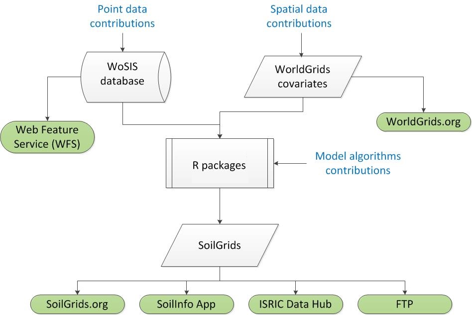
Simplified representation of ISRIC's cyber-infrastructure for soil data standardisation, mapping and spatial modelling
Who is it for?
We aim at serving various communities.
- The international science community: SoilGrids is currently used by (global) modellers, for instance for modelling earth-atmosphere interactions, climate change, hydrological processes and crop growth.
- Agricultural research and development organizations, such as FAO, UNEP, UNCCD, CGIAR's, USAID, World Bank and similar, in need of quality-assessed spatial information on soil and land.
- Soil survey agencies (or other players) that want to produce a national soil information system. In this context SoilGrids can be used to help developing a sampling design for the area of interest. Parties that wish to produce their own national or regional scale soil maps can use SoilGrids routines freely and use SoilGrids maps as covariates in the process.
- Parties that do not have this desire and / or capacity can upload their additional point observations to our repository and ISRIC will produce an improved map of the area of interest.
- We also aim at serving national environmental agencies, private entities, soil scientists, farmers, agriculture engineers and other interested parties.