New paper released: SoilGrids 2.0, Soil information for the globe
A newly released paper, SoilGrids 2.0: producing soil information for the globe with quantified spatial uncertainty, provides a peer-reviewed scientific publication describing the production of SoilGrids, ISRIC – World Soil Information’s flagship system for global digital soil mapping.
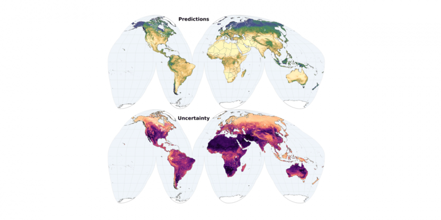
SoilGrids is comprised of quality-assessed global maps of soil properties. In the latest version of SoilsGrids, released in 2020, ISRIC introduced many methodological improvements such as: an improved set of point observations with more stringent quality assessment as well as improved cross-validation and covariate selection methods. SoilGrids also gained spatially explicit uncertainty quantification.
"SoilGrids presents global soil maps that can underpin many environmental applications at global and large regional scales which are needed to achieve the Sustainable Development Goals." Rik van den Bosch, ISRIC director
In this research paper published in the journal SOIL, SoilGrids 2.0 maps received quantitative and qualitative scientific evaluation for soil organic carbon content, total nitrogen, coarse fragments, pH(water), cation exchange capacity, bulk density and texture fractions at six standard depths (up to 200 cm). SoilGrids includes spatial uncertainty information with the 0.05 and 0.95 quantiles for the different soil properties. The qualitative evaluation of SoilGrids showed broadscale patterns are well reproduced.
“Soil information is fundamental to address many environmental challenges. SoilGrids presents global soil maps that can underpin many environmental applications at global and large regional scales which are needed to achieve the Sustainable Development Goals, ” said ISRIC Director Rik van den Bosch. “The improvements offered by SoilGrids 2.0 are not always fully visible for all users, but these changes offer robust evaluation and potential automatization of the mapping process."
It is also important to note that with datasets intended for use at global scale, such as SoilGrids, caution is necessary when applying the data at local scale and looking at smaller areas.
ISRIC senior researcher and digital soil mapping specialist Laura Poggio is lead author on this paper with several ISRIC colleagues as co-authors including Luis de Sousa, Niels Batjes, Gerard Heuvelink, Bas Kempen, Eloi Riberio (former ISRIC colleague), and ISRIC guest researcher David Rossiter.
Access the paper here: https://soil.copernicus.org/articles/7/217/2021/