21 Jun 2018

SQAPP (Soil Quality Mobile App), is an easy-to-use tool that brings global soil data into the decision-making sphere of land users and other interested end users. It returns available soil quality information for any location in the world, simply picked by the user from a world map. Soil properties for that specific location are then shown and possibilities are offered to assess these values and to adapt them if necessary.

07 Jun 2018

ISRIC – World Soil Information, within in the framework of project led by CIAT (International Center for Tropical Agriculture, Nairobi), provided expertise for an assessment of soil organic carbon (SOC) stock baselines for the Otjozondjupa region in Namibia. This was done in support of Sustainable Development Goal (SDG) Target 15.3 the aims of which is to achieve global land degradation neutrality (LDN) by 2030. Different sampling densities and digital soil mapping methods were compared and evaluated in terms of complexity, cost, and map accuracy.

31 May 2018

This week (28 May – 1 June, 2018)  ISRIC - World Soil Information organized the sixth edition of the ISRIC Spring School on 'Mapping, classification and assessment of soils'.

Sixty-four participants from 28 countries attended the course. Two thirds of the participants focussed on spatial predictions of soil properties and soil classes using digital soil mapping. The other participants followed lectures and practicals about soil classification and their assessment. 

31 May 2018

ISRIC – World Soil Information, carried out a review of long-term experiments for Europe and China to assess effects of agricultural management practices on soil quality. This work was done in the framework of the EU-China funded project iSQAPER.

31 May 2018

ISRIC’s most important work in relation to collaborative projects on “Food security”, “Sustainable land Management and Land degradation neutrality” and “Mitigation and adaptation to climate change” is summarised in our Highlights for 2016-2017. We have refined our medium-term strategy, which included redefining our mission statement and structuring our four work streams: soil standards and reference; soil information provisioning; building an effective user community; and co-production of derived products. A key event in 2017 has been the celebration of our 50th Anniversary.

20 Apr 2018

An international group led by researchers at the Woods Hole Research Center (WHRC) and ISRIC – World Soil Information have compiled a large geo-referenced database of mangrove soil carbon measurements and developed a global map of mangrove forest soil carbon at 30 m spatial resolution. The map can help nations seeking to include mangrove habitats in payment-for-ecosystem services projects and in designing effective mangrove conservation strategies. The map and model outputs are freely available from Harvard Dataverse.

02 Apr 2018

On 29th March 2018, we celebrated the completion of a 7-year program aiming at further improvement of the quality and accessibility of the World Soil Reference Collection. During this international event various speakers highlighted the relevance of the collection and its potential in addressing a range of contemporary societal and environmental challenges. 

22 Mar 2018

Together with the International Centre for Tropical Agriculture (CIAT), ISRIC organised a workshop from 13 to 16 March 2018 in Windhoek, Namibia to support the development of baseline maps of Land Degradation Neutrality (LDN) indictors for the Omusati Region.

12 Mar 2018

Save the date and join the seminar: “The World Soil Reference Collection: a unique source for research and education” on 29th March, 2018.

Programme: 13.45 – 16.30 (closure with drinks) 


Venue: Wageningen Campus, Droevendaalsesteeg 3, room GAIA 1

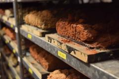
ISRIC has implemented a global sampling scheme to broaden its world soil reference collection. During this 7 year project the quality and accessibility of the World Soil Reference Collection has been improved. 


09 Mar 2018

We have updated the technical report describing the workflows and procedures for standardising and harmonising soil profile data in WoSIS (World Soil Information Service), our centralised database. We focussed on the standardisation of analytical method descriptions for soil properties listed in the GlobalSoilMap specifications.

The work builds on contributions from numerous data providers and experts, for which we are thankful.