Background
The SOTER programme was initiated in 1986 by the Food and Agricultural Organization of the United Nations (FAO), the United Nations Environmental Programme and ISRIC, under the auspices of the International Soil Science Society. The aim of the programme was to develop a global SOTER database at scale 1:1 million that was supposed to be the successor of the FAO-UNESCO Soil Map of the World. A SOTER database with global coverage was never achieved, but SOTER databases were developed for various regions, countries and continents. Typically, SOTER databases are developed in collaboration with a range of partners.
A SOTERTM database is composed of a map (in GIS polygon format) that delineates the SOTER map units and a set of tables in a relational database (in MS Access or PostGreSQL format) with terrain and soil data. The information in the table can be linked to the units of the map.
Coverage of SOTER
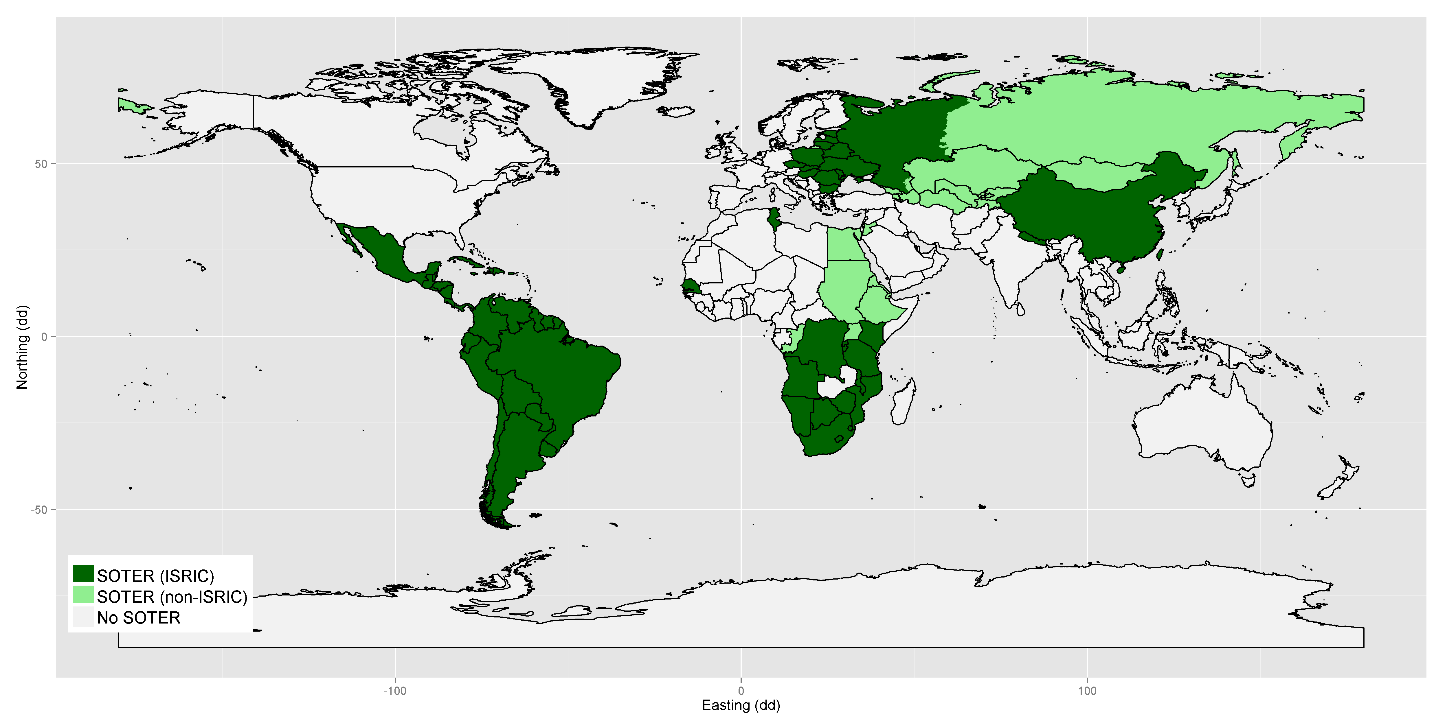
SOTER products have been developed for some 30 countries, by various lead organisations, and at various scales. The map below provides an overview of the state of SOTER coverage in 2013:
At continental scale: Latin America (SOTERLAC) (1:5M)
At regional scale: Southern Africa (1:2M) | Central Africa (1:1M-1:2M) | Central and Eastern Europe (SOVEUR) (1:2.5M)
At national level: Argentina (1:1M) | Cuba (1:1M) | China (1:1M) | Kenya (KENSOTER) (1:1M) | Malawi (1:1M) | Nepal (1:1M) | Senegal & Gambia | (1:1M) | South Africa (1:1M) | Tunisia (1:1M) | Uruguay (1:1M)
At district level: Upper Tana Catchment (Kenya; 1:250k) | Hainan (China; 1:250k)
Non-ISRIC SOTER products: Northern Eurasia (1:5M; FAO) | North-eastern Africa (1:1M-1:2M; FAO) | Congo (1:1M; ILMW-Univ. Leuven) | Southwest Niger (1:200k; Univ. Hohenheim) | Southern Benin (1:200k; Univ. Hohenheim) | Hungary (1:500k; RISSAC) | Jordan (1:500k)
From SOTER to SOTWIS
 Soil profile data in the SOTER databases are often incomplete, which hampers their applicability for quantitative studies. To overcome this, consistent taxo-transfer rules, developed during the WISE project, were used to fill gaps in the SOTER soil profiles. These derived databases are referred to a SOTWIS products. From these soil profiles, a consistent set of 18 soil properties was derived for depth intervals of 20 cm up to 100 cm depth. The soil properties include: organic carbon, total nitrogen, pH, cation exchange capacity, base saturation, aluminum saturation, calcium-carbonate and gypsum content, exchangeable sodium, electric conductivity, bulk density and the sand, silt and clay fractions.
An important application has been to provide updated materials for the SOTER-covered sections of the Harmonised World Soil Database (HWSD), which is an interim update to the FAO-UNESCO Soil Map of the World.
SOTWIS products (in alphabetic order):
Brazil | Central Africa | Central & Eastern Europe | India, Indo-Gangetic Plains | Jordan | Kenya | Upper Tana (Kenya) | Latin America & The Caribbean | Senegal & The Gambia | Southern Africa | Tunisia