Soil Information Systems

High-quality soil information supports better decisions about how we manage and protect our soils. Healthy soils are essential for climate resilience, food security, sustainable land management, biodiversity, and water security. Yet soil information is often scattered, inconsistent, or difficult to access.

Soil Information Systems (SIS), empowered by the Findable, Accessible, Interoperable, and Reusable (FAIR) principles, can help address these challenges by storing and sharing soil data, information, technologies, and knowledge. SISs support better decision-making by providing evidence-based information across scales, from national to continental level, benefiting a wide range of users, from agricultural advisors to researchers, policymakers, industry and international initiatives.
What is a Soil Information System?

A Soil Information System (SIS) is a set of integrated components that collect, organise, integrate, manage and provide access to information about soils to support understanding and decision-making. A SIS is much more than a soil database or unique platform; it makes use of diverse set of technologies, tools and standards to store and serve soil data and information.

A SIS typically contains georeferenced soil observations with associated analytical data describing soil conditions, as well as digitised or digital (gridded) soil maps. These maps can represent soil classes or basic soil properties, such as pH, organic carbon, and texture, as well as soil functional characteristics such as erosion risk and soil water content.

A SIS can also be integrated with or connected to other platforms that provide complementary environmental data, such as information on climate, crops, landscape, and socio-economic conditions, as well as digital advisory tools. Combining a SIS with such platforms enables the development of more effective decision-support tools and supports better-informed decision-making.

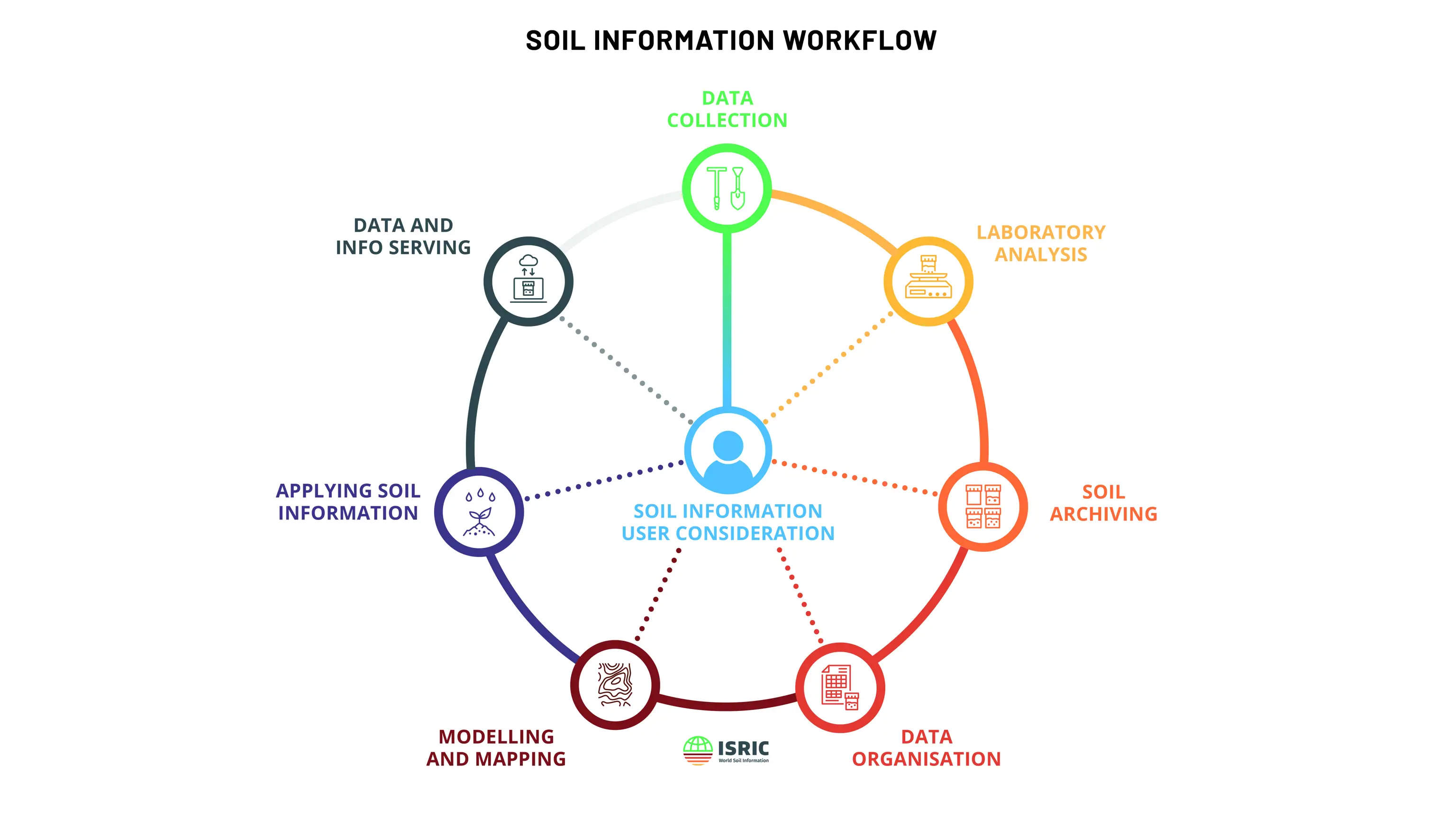
The Soil Information Workflow shows the various elements of a SIS

Challenges and long-term sustainability

A SIS is often developed as part of a short-term project (typically 4-5 years). When the project ends, the SIS may become non-functional, as it is often viewed only as a technology output rather than an ongoing process of collaboration and development. Moving SIS beyond short-term, donor-funded projects into sustainable, operational systems remains a major challenge. Common challenges include:

  1. Lack of sustainable governance plans. 

  2. Lack of funds to maintain the SIS. 

  3. Insufficient understanding of user needs. 

  4. Limited technical expertise for system maintenance and development. 

  5. Fragmented and poorly documented soil datasets, including inconsistent data standards and formats. 

  6. Lake of clear data licensing and policies for data users and data producers.

Addressing these challenges requires coordinated action, long-term investment, strong institutions, and continued attention to user needs. Developing and implementing a SIS therefore requires collaboration among diverse stakeholders, including government bodies, research institutions, non-governmental organisations (NGOs), agricultural extension services, farmers’ associations, private sector, and international organisations. Many countries have recognised the importance of SIS and have invested in their development. However, their expansion remains limited.

By supporting national ownership, regional collaboration, and global interoperability, ISRIC and its partners help build resilient, data-driven SIS that support sustainable land management, food security, and environmental stewardship worldwide.

For over 60 years, ISRIC has been dedicated to developing and applying soil information and knowledge for the benefit of society. As the World Data Centre for Soils, data stewardship, soil information and its accessibility are at the very core of our work.

— Rik van den BoschDirector of ISRIC

ISRIC's contributions across scales

ISRIC has a long history of developing soil datasets and soil maps, as well as digital systems for disseminating this information to users.

In 1986, ISRIC was one of the founding organisations of the Soil and Terrain (SOTER) programme together with the Food and Agricultural Organization of the United Nations (FAO) and the United Nations Environmental Programme (UNEP). The SOTER programme provided a standard for storing soil and terrain information in digital format, allowing standardisation and harmonisation of such data between geographic regions. It was one of the first initiatives to make digital soil data and information interoperable. SOTER can therefore be considered a pioneering precursor to today’s SIS, which rely on modern, web-based technologies to store, manage and disseminate spatial data. Read more on SOTER: Soil and Terrain (SOTER) database programme.

In 2013, ISRIC established its World Soil Information Service (WOSIS), a centralised global soil service that serves harmonised data. This service is unique in the world and managed and maintained by ISRIC as a global public good.

Building on its decades of experience in supporting the development of SIS, ISRIC, together with its partners, currently focuses on strengthening SIS capacities in Africa at different scale levels, with plans to expand these efforts to other regions in the Global South.

Below is an overview of ISRIC's contributions to the development and strengthening of SIS, highlighting initiatives and activities undertaken at national, regional, and continental levels worldwide.

Interested to learn more?

Are you interested in developing or improving a soil information system? Get in touch to learn more or discuss opportunities for collaboration.