Two ISRIC-supported MSc students successfully defend their research
Digital soil maps are key tools for many people -- conservation planners, climate change modellers, and agriculture advisors to name a few. However, the data available to generate soil maps often have a high level of uncertainty and needs rigorous accuracy assessment in order to be a reliable tool for decision-making. At ISRIC – World Soil Information, we were pleased to support the work of two MSc students, Tom van Ebbenhorst Tengbergen and Chloé Girka, to produce research on soil data accuracy assessment methods and mapping with uncertain soil data.
On February 24, 2021, Chloé and Tom successfully presented their research on these topics in the Wageningen University’s master program in geo-information science (MGI).
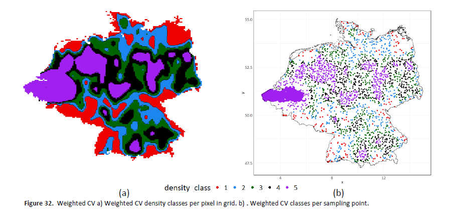
Tom’s research, “Critical evaluation and improvement of cross-validation strategies for accuracy assessment of digital soil maps” was supervised by associate professor Sytze de Bruin in the Wageningen University’s Laboratory of Geo-information Science and Remote Sensing as well as senior ISRIC researchers Gerard Heuvelink and Laura Poggio. Within this study, he focused on the bias found in the accuracy assessment of different CV methods when soil samples were spatially unevenly distributed (i.e. clustered) across the study area. By using a simulation approach where all soil values within a discretized grid were known, Tom was able to compare the estimated accuracy of each CV method with the true accuracy. He found that one of his newly designed CV methods, weighted CV, showed the least deviation from the true accuracy error within spatially clustered datasets. Could this result potentially lead to a more accurate evaluation of digital soil maps derived from clustered datasets? At the least it invites further research.
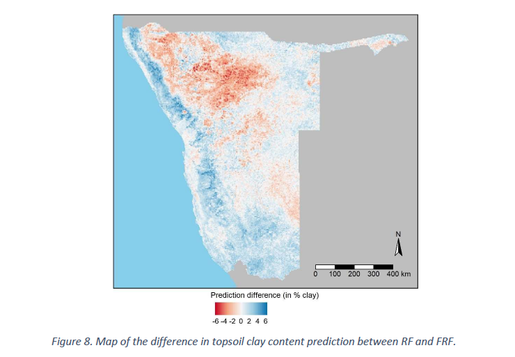
Chloé’s research, "Digital Soil Mapping with Uncertain Data,” was supervised by Gerard Heuvelink, who also holds the title special professor in pedometrics and digital soil mapping at Wageningen University, Sytze de Bruin and PhD candidate Stephan van der Westhuizen. She addressed how to account for measurement uncertainties in statistical validation of digital soil maps, and analysed the effects of either ignoring or acknowledging measurement errors in the fitting of random forest digital soil mapping models. The objective of her thesis, was to compare regular random forest and filtered random forest in a real-world case study of mapping topsoil clay content in Namibia. Random forest and filtered random forest showed similar predictions and performances. As heterogeneity in measurement uncertainty increased, filtered random forest gradually outperformed random forest, indicating that filtered random forest could be suitable for integrating training data of varying sources and quality.
“Both Tom and Chloé have made important contributions to the advancement of digital soil mapping research. Their work is already being incorporated in our own research and will help improve the digital soil mapping procedures applied at ISRIC – World Soil Information and Wageningen University.” Prof. Heuvelink said.
Visit the ISRIC Student page to read bios for Chloé and Tom and ISRIC PhD page for Stephan van der Westhuizen’s bio.
Wageningen University’s master program in geo-information science (MGI) is a two-year experience for students where they look at how to use geo-information to find solution for challenges such as flooding, tropical forest management, animal migration and urban planning. To learn more about the program, visit the MGI webpage.