Ever-increasing demands on the land from economic development, burgeoning cities, and growing rural populations are driving unprecedented land-use change. In turn, land-use change is driving land degradation: soil erosion, nutrient depletion, salinity, water scarcity, pollution, disruption of biological cycles, and loss of biodiversity. This is a global issue (UNCED 1992, UNEP 2006), yet there is no authoritative measure of land degradation or its counterpoint – land improvement. The only harmonized assessment, the Global Assessment of Human-induced Soil Degradation is a map of perceptions on the type and degree of degradation. Dating from 1991, it is now out-of-date.
There is a pressing need for an up-to-date, quantitative and reproducible assessment to support policy development for food and water security, environmental integrity, and national strategies for economic development and resource conservation. In response, within the GEF-UNEP-FAO program Land Degradation in Drylands, the Global Assessment of Land Degradation and Improvement (GLADA) will identify:
- The status and trends of land degradation, and
- Hotspots suffering extreme constraints or at severe risk and, also, areas where degradation has been arrested or reversed.
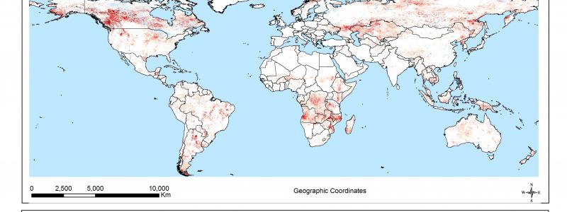
Biomass is an integrated measure of biological productivity. Its deviance from the local norm may be taken as a measure of land degradation or improvement. Changes in biomass may be measured by remote sensing of the normalized difference vegetation index (NDVI - the difference between reflected near-infrared and visible wavebands divided by the sum of these two wavebands). NDVI has a strong, linear relationship with the fraction of photosynthetically active radiation absorbed by the plant; it is strongly correlated with vegetation cover and above-ground net primary productivity. Norms may be established by stratifying the land area according to climate, soils, and terrain, and land use/vegetation; deviance may then be calculated regionally and combined globally to allow universal comparisons.
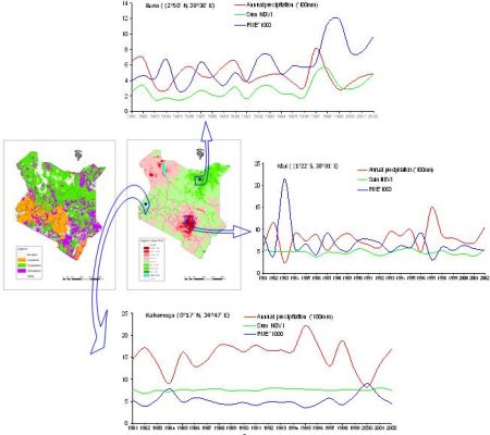
GLADA pilot study for Kenya
FAO has commissioned ISRIC to undertake pilot studies to:
- Elaborate the general approach to map global land degradation by analysis of the GIMMS dataset of 8km-resolution NDVI data;
- Analyze other global databases, in particular, the Soil and Terrain Database (SOTER), in support of the general NDVI methodology;
- Illustrate the approach developed under 1 and 2 with case studies in Kenya (PDF) and North China (PDF) ;
- Compare the results for Kenya with results from a high-resolution land cover change study produced by the Global Land Cover Network.
Methods
The general approach developed for GLADA involves a sequence of analyses to identify land degradation hotspots using remotely sensed data and existing datasets: first using simple NDVI indicators such as mean annual sum NDVI (surrogate for mean annual biomass production) and the trend of biomass production; secondly integration of biomass and climatic data (rain-use efficiency); thirdly, stratification of the landscape using land cover and soil and terrain data to enable a more localized analysis of the NDVI data. Most of the development work has gone into algorithms that enable these screening analyses to be undertaken automatically. At the next stage, the identified hotspots will be characterized manually, using 30m-resolution Landsat data, to identify the probable kinds of land degradation, preliminary to field examination by national teams within the wider LADA program.
Publications
Bai ZG, Jong de R, van Lynden GWJ 2010. An update of GLADA – Global assessment of land degradation and improvement. ISRIC report 2010/08, ISRIC – World Soil Information, Wageningen, 58p
PDF
Bai ZG, Dent DL, Olsson L and Schaepman ME 2008. Global Assessment of Land Degradation and Improvement. 1 Identification by remote sensing. Report 2008/01(GLADA Report 5), ISRIC – World Soil Information, Wageningen, 70p
PDF
Bai ZG and Dent DL 2007. Land degradation and improvement in Tunisia. 1: Identification by remote sensing. Report 2007/08 (GLADA Report 1f), ISRIC – World Soil Information, Wageningen, 47p
PDF
Bai ZG and Dent DL 2007. Land degradation and improvement in Senegal. 1: Identification by remote sensing. Report 2007/07 (GLADA Report 1e), ISRIC – World Soil Information, Wageningen, 48p
PDF
Bai ZG and Dent DL 2007. Land degradation and improvement in China. 1: Identification by remote sensing. Report 2007/06 (GLADA Report 1d), ISRIC – World Soil Information, Wageningen, 52p
PDF
Bai ZG and Dent DL 2007. Land degradation and improvement in Argentina. 1: Identification by remote sensing. Report 2007/05 (GLADA Report 1c), ISRIC – World Soil Information, Wageningen, 50p
PDF
Bai ZG and Dent DL 2007. Land degradation and improvement in Cuba. 1: Identification by remote sensing. Report 2007/04 (GLADA Report 1b), ISRIC – World Soil Information, Wageningen, 48p
PDF
Bai ZG and Dent DL 2007. Land degradation and improvement in South Africa. 1: Identification by remote sensing. Report 2007/03 (GLADA Report 1a), ISRIC – World Soil Information, Wageningen, 54p
Other reports and news on the Land Degradation Assessment (LADA) Project are available from the FAO LADA website