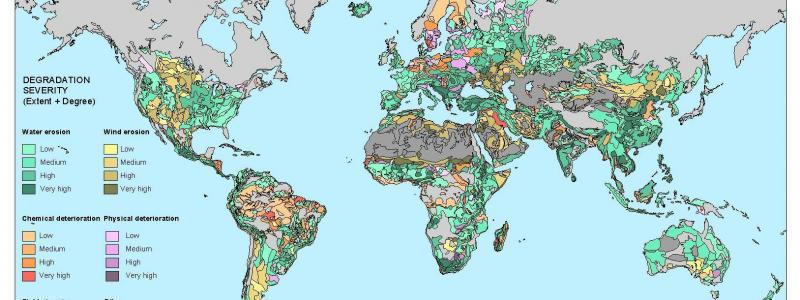
Global Assessment of Human-induced Soil Degradation (GLASOD)
The UNEP-funded GLASOD project has produced a world map of human-induced soil degradation, using a expert-based approach.
The UNEP-funded, GLASOD project has produced a world map of human-induced soil degradation. Data were complied in cooperation with a large number of soil scientists throughout the world, using uniform Guidelines and international correlation . The status of soil degradation was mapped within loosely defined physiographic units (polygons), based on expert judgement . The type, extent, degree, rate and main causes of degradation have been printed on a global map, at a scale of 1:10 million, and documented in a downloadable database. Information about the areal extent of human-induced soil degradation can be found in an explanatory note.
GLASOD applications:
- International policy makers and planners (e.g. UNEP, FAO, WRI)
- National policy makers and planners
- International conventions and programmes (CCD, Kyoto protocol, UN-CPB, IGBP)
- Researchers at national and international level (NARI’s, CGIAR, universities)
- Education professionals (teachers, professors, etc.) and students
- Environmental organisations (general public awareness)
GLASOD limitations:
- Small scale: not appropriate for national breakdowns
- Expert judgement: qualitative and (potentially) subjective
- Limited number of attributes due to cartographic restrictions
- Visual exaggeration: each polygon which is not 100% stable shows a degradation colour, even if only 1 to 5% of the polygon is actually affected
- Extent classes (5) rather than percentages
- Complex legend: combined extent and degree (severity) for four major degradation types (water and wind erosion, physical and chemical deterioration)
- Only “dominant” main type of degradation is shown in colour
- Degradation sub-types only shown by codes
- Only “bad news”
Follow-up assessments:
- Regional assessments of soil degradation status - South and Southeast Asia (ASSOD), Central and Eastern Europe (SOVEUR)
- Land Degradation Assessment in Drylands (LADA) - Global project, under UNEP/FAO. ISRIC and WUR Centre for Geo Information are responsible for the spearpoint Global Assessment of Land Degradation and Improvement based on 22 years of fortnightly NDVI data [2006 - 2009]


