 of the Central European window")
Background
![]() The e-SOTER project that ran from September 2008 until February 2012, is a European contribution to a global soil observing system as part of the Global Earth Observing System of System (GEOSS). The kick-off meeting was at ISRIC, Wageningen, from 11 to 12 September, 2008.
The e-SOTER project that ran from September 2008 until February 2012, is a European contribution to a global soil observing system as part of the Global Earth Observing System of System (GEOSS). The kick-off meeting was at ISRIC, Wageningen, from 11 to 12 September, 2008.
The EU Framework Programme 7 (FP7) funded the research through a grant of €2.6 million. Coordinated by ISRIC –World Soil Information, it brought together 12 research organizations from Europe as well as tow from non-European countries.
The Challenge
Soil and land information is needed for policy-making, management of land resources, and monitoring of the environmental impact of development. Soils are under threat from various human activities and, for sustainable use and management, comprehensive information on their attributes and response to management is essential. This information is lacking, European-wide and globally. The traditional data collection process is slow and expensive; a Global Earth Observation System can plug the gaps in our knowledge faster and at lower costs and deliver the information effectively to a wide range of users. e-SOTER is proposed as the European contribution to a Global Soil Observing System, overcoming the present shortcomings of SOTER and providing a Regional Pilot Platform that can be extended worldwide.
e-SOTER adds value by:
- using remotely-sensed data both to validate and correct existing survey data
- generating new data surfaces
- improving the quality of results of applications previously based on legacy data alone
- providing a freely accessible web service that delivers both selected data in an easy-to-use format and procedures to compile e-SOTER databases locally and upload these data to the European database if they meet prescribed quality standards.
Project Objectives
The project addressed four major barriers to a comprehensive soil observing system:
- Morphometric descriptions - enabling quantitative mapping of landforms as opposed to crude slope categories. This will build upon EU- initiated DEM landform classification procedures;
- Soil parent material characterization and pattern recognition by remote sensing - enabling separation of soil processes within the landscape;
- Soil pattern recognition by remote sensing;
- Standardization of methods and measures of soil attributes to convert legacy data already held in the European Geographical Soil Database and various national databases to a common standard - so that they may be applied, e.g. in predictive and descriptive models of soil behavior.
The project objectives that contribute to the lifting of the four major barriers described above are:
- Morphometric descriptions of the landforms both in an enhanced SOTER DEM methodology as well in newly developed DEM analysis using natural breaks. The existing DEM that will form the basis for the morphometric analysis will be filtered and enhanced to obtain an artifact-free product. The end product will be a landform layer in the 1:1 million scale window and 1:250 000 scale pilot areas.
- Soil parent material characterization using remote sensing and legacy data will generate a parent material classification relevant for soil development, and parent material pattern within the window and pilot areas.
- Soil pattern recognition will use existing data and converting these into a standardized SOTER format. Remote sensing will generate additional predictors of soil properties. End products will be a soil layer in the window and pilot areas with standardized soil attributes.
Additional project objectives were:
- Quality assessment of e-SOTER through validation and uncertainty analysis.
- Applications of the newly acquired e-SOTER in the field of major soil threats and comparisons with applications based on earlier datasets.
- Dissemination of the results of the project through stake-holder conferences and through web-based services.
The Methodology
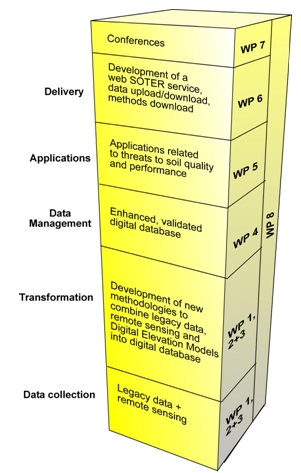 e-SOTER has two major research thrusts: (1) improvement of the soill information system at a continental scale (four windows at scale 1:1 Million in Western Europe, Central Europe, Morocco and South China) using moderate-resolution optical remote sensing systems to delineate landform units and to associate them statistically with existing soil parent material and soil information, and (2) development of advanced methodologies at a regional scale (three pilot areas at scale 1:250 000 in the UK, Germany/Czech Republic, and Morocco) using geomorphic landscape analysis, geological re-classified remote sensing, and remote sensing of soil attributes. End products will be a layer of soil information with standardized soil attributes for the 1:1 Million and the 1:250 000 scale. The project will quantitatively assess the quality of the developed products and compare the evaluation of soil threats using both the e-SOTER database and existing soil data.
Results
The end product is a regional pilot platform with methodologies, concepts and applications that, together, will facilitate: (1) an enhanced methodology to develop SOTER databases at scale 1:1 million for Europe and the world; (2) ways of generating finer-scale maps of specific soil and terrain attributes, and digital data based on existing soil survey data and remote sensing; (3) a framework for new, cost-effective programs of field survey and monitoring. Natural resources organizations will benefit from the new methodology and may use the framework for data collection and monitoring. This will enable enhancement of standard soil information at a European and national level and decisions on land use and management will be based on better information.
The results also contribute to the development of a Global Soil Observing System.
Projects Partners
| Organization | Country |
|---|---|
| ISRIC - World Soil Information (coordinator) | NL |
| Dept of Physical Geography and Environmental Sciences, University of Miskolc | HU |
| Spatial Information in Soil and Environmental Protection, Federal Institute for Geosciences and Natural Resources | GE |
| European Commission, DG JRC, IES, Land Management & Natural Hazards Unit | IT |
| National Soil Resources Institute, Cranfield University | UK |
| Alterra – Green World Research | NL |
| Dept of Soil Science and Agricultural Chemistry, Szent Istvan University | HU |
| Scientific Landscapes GmbH | GE |
| Science du Sol, Institut National de Recherche Agronomique | FR |
| Centre for Geospatial Science, University of Nottingham | UK |
| Czech University of Life Sciences | CZ |
| Institute of Soil Science, Chinese Academy of Sciences | China |
| Ecole Nationale d’Agriculture de Meknès | Morocco |
| Laboratory for Geo-information Science and Remote Sensing, Wageningen University | NL |